Protected Areas
We conserve the most valuable ecosystems of Chaco, Chiquitania, Pantanal and Amazon, guaranteeing their wealth for future generations

Protected areas are the heart of our biodiversity and natural heritage
From the vastness of the Pantanal to the ecological richness of the Amazon, these areas represent a A collective commitment to preserving life.💚 Learn about each of the areas we protect and their importance for a sustainable future.
Discover the protected areas
Access more information from our menu by clicking here.
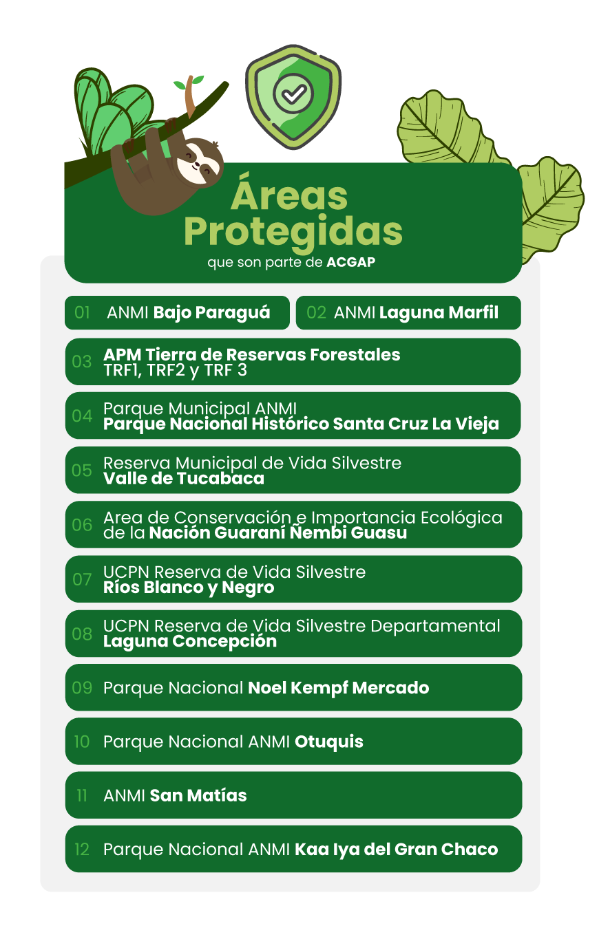
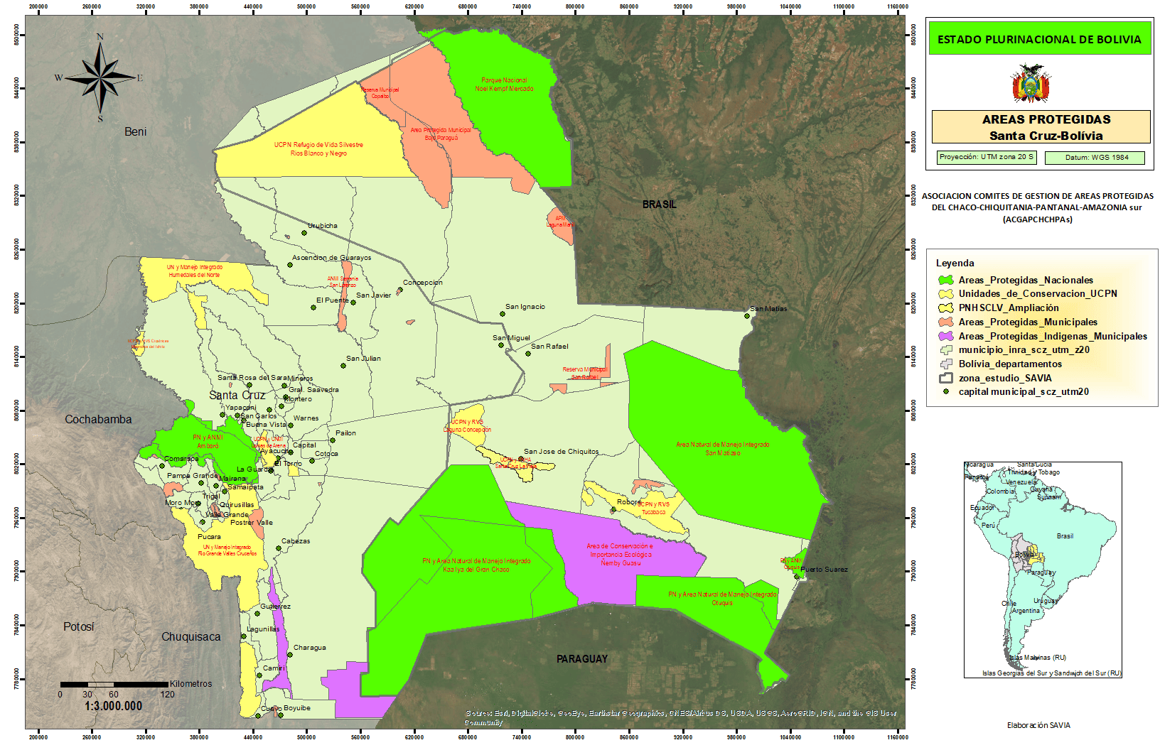
Map of Protected Areas: Guardians of Biodiversity
Explore the map of protected areas in Santa Cruz, Bolivia, which reflects collaborative efforts to conserve key ecosystems. From national parks to municipal and indigenous reserves, these areas represent a commitment to protecting the natural and cultural wealth of our region.
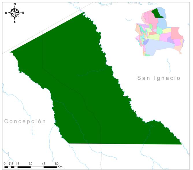
ANMI Under Paraguá
Bajo Paraguá Municipal Protected Area
Established on February 12, 2021, by Municipal Law No. 469/2021, the Bajo Paraguá Municipal Protected Area is located in the municipality of San Ignacio de Velasco, in the northern part of the department of Santa Cruz. Covering an area of 9,830.06 km², this area encompasses the Chiquitano Forest ecoregion and part of the Amazon rainforest, conserving rich biodiversity and unique cultural values.
The region is home to four Indigenous communities: three Chiquitano and one Guarasugwe. Furthermore, the area borders important protected areas such as Noel Kempff Mercado National Park and Copaibo Municipal Protected Area, forming part of a key biological corridor for the conservation of emblematic and endangered species.
With an average temperature of 24°C and a landscape characterized by alluvial plains, hills, and Precambrian rock outcrops, the Lower Paraguá region represents a model of environmental management and cultural protection. Its creation aims to mitigate the effects of irregular settlements and guarantee the preservation of natural resources against human pressures.
ANMI Ivory Lagoon
Created on the 1stOctober 2, 2010 through Municipal Ordinance No. 140/2010 Reinforced by Municipal Law No. 448/2020, the Laguna Marfil Integrated Management Natural Area is located in the municipality of San Ignacio de Velasco, within the Velasco province of Santa Cruz. This area conserves a body of water of great importance known as Laguna Marfil, which shares a lake border with Brazil.
The lagoon, also called “Baia Grande” In Brazil, it covers an area of 97.5 km², of which 52.2 km² belong to Bolivia. The region is notable for its unique ecosystems of open forests, pampas, and savannas, which harbor a great diversity of species. Its proximity to Noel Kempff Mercado National Park makes it a key point for ecological connectivity and the protection of biological corridors. Furthermore, it is home to Chiquitano communities, who depend on the area for their subsistence through sustainable practices such as fishing and agriculture.
The main objective of the area is to protect water resources and biodiversity While promoting the sustainable use of natural resources, Laguna Marfil is also a tourist attraction due to its scenic beauty and potential for activities such as ecotourism and recreational fishing.

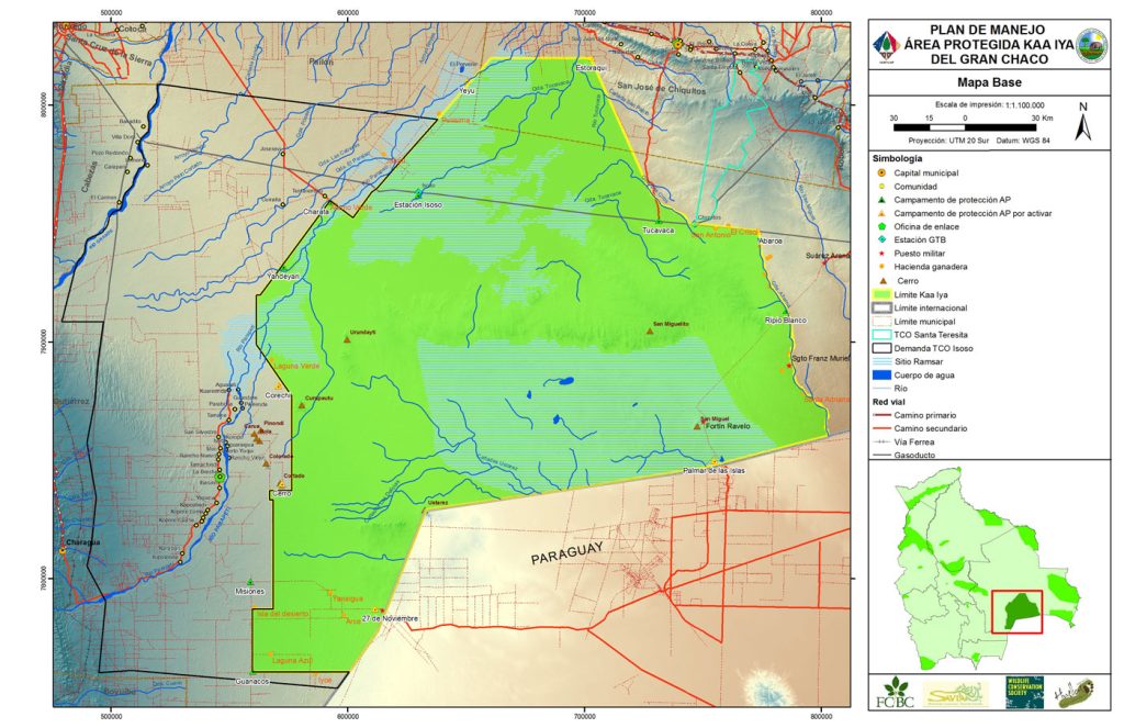
Kaa Iya of the Gran Chaco
Kaa Iya del Gran Chaco National Park and Integrated Management Natural Area, created on September 21, 1995 by Supreme Decree No. 24122,It is the largest protected area in Bolivia, covering 3,441,115 hectares. It represents the best-preserved tropical dry forest in the Northern Chaco and is an example of large-scale conservation. This park is unique for its biodiversity and its role in protecting endangered species such as the Chaco guanaco, the jaguar, and numerous endemic birds.
The Kaa Iya is not only notable for its ecological richness, but also for being a key space for the subsistence and development of the Isoseña, Ayorea and Chiquitana indigenous communities, whose traditional rights are respected within its management. It also includes Ramsar sites such as the Bañados del Izozog and the Parapetí River, which are important for water regulation and wetland conservation.
Its Management Plan focuses on balancing environmental conservation with sustainable development, It serves as a model for the management of protected areas in the Chaco region. This park reflects a commitment to the protection of biodiversity and the harmonious coexistence between local communities and nature.
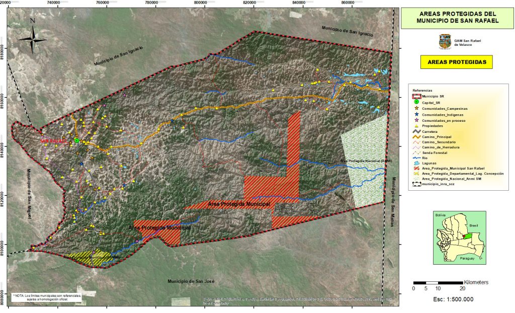
APM Saint Raphael
Municipal Protected Area San Rafael Reserve Established in 2006 by Municipal Ordinance No. 15/2006, the San Rafael Reserve is located in the municipality of San Rafael de Velasco, Velasco Province, Santa Cruz. Covering 69,143 hectares distributed across three interconnected polygons, this protected area aims to conserve the tropical dry forest, a key ecosystem of the Chiquitania region.
The area boasts rich biodiversity with 83 species of fish, 69 of birds, and 26 of mammals, as well as reptiles such as caimans and snakes. Its ecological diversity contributes to the connectivity between the region's ecosystems and reinforces its role as a key conservation area within the Chiquitano Dry Forest.
The management of the reserve seeks to balance environmental conservation with sustainable development, promoting the care of natural resources and biodiversity, essential for the region and its communities.
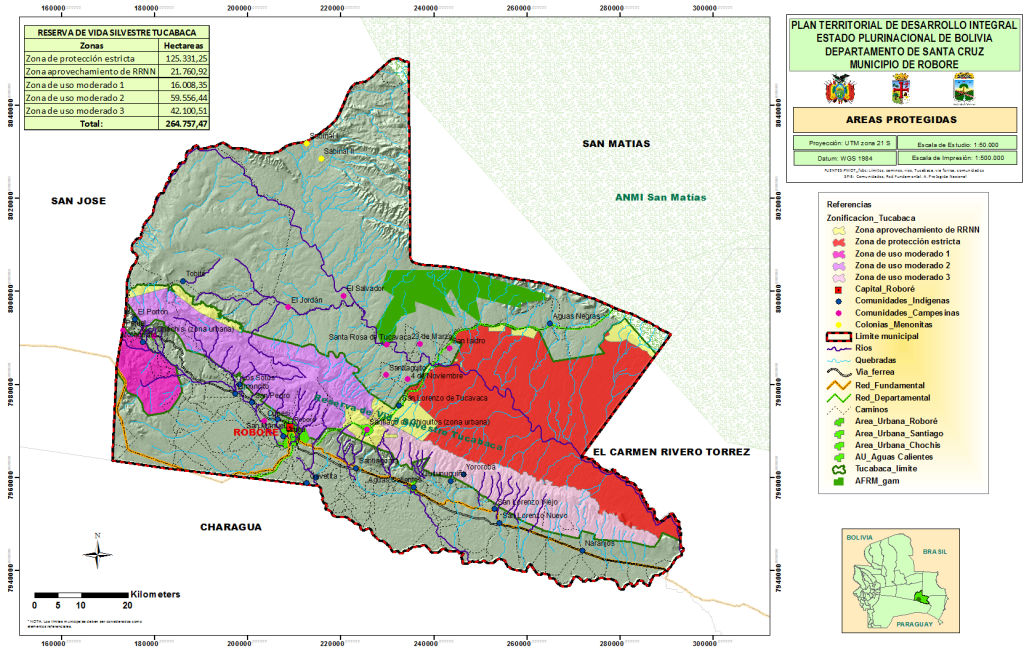
Protected Area Tucabaca
Municipal Protected Area Tucabaca Wildlife Reserve
Established in 2000 by Municipal Ordinance No. 05/2000, the Tucabaca Wildlife Reserve is located in the municipality of Roboré, Chiquitos Province, Santa Cruz. Covering approximately 262,305 hectares, this protected area forms part of the Chiquitano Dry Forest, considered one of the most biodiverse and best-preserved ecosystems in Bolivia.
The reserve is renowned for its unique landscapes, such as the Serranía de Santiago mountain range and the Tucabaca Valley, which offer a combination of scenic beauty and biodiversity. Its main objectives include the conservation of water resources, the protection of endemic species, and the promotion of sustainable activities in the region. Furthermore, its strategic location makes it a key biological corridor connecting different protected areas and ecosystems.
The Tucabaca Reserve is also home to local communities that actively participate in its management, promoting a balance between conservation and the responsible use of natural resources. This inclusive governance model has allowed Tucabaca to become a leading example of integrated conservation in the country.
National Park Old Santa Cruz
Created in 1989 by Supreme Decree No. 22077, The Santa Cruz la Vieja Historical National Park is located in the Chiquitos province, Santa Cruz department, Bolivia. It covers an approximate area of 17,080 hectares, This park protects both the historical heritage of the founding of Santa Cruz de la Sierra in 1561 by Ñuflo de Chávez and the ecosystems of the Chiquitano Dry Forest.
The park is home to a great diversity of flora and fauna, It is a key refuge for species such as the jaguar, the puma, and various endemic birds. Furthermore, it protects the archaeological remains of the original settlement of Santa Cruz, making it a space of great cultural and natural significance.
Among its main objectives are the conservation of natural resources, The park promotes scientific research and the preservation of the region's historical heritage. It also fosters sustainable tourism, inviting visitors to explore its rich cultural and ecological heritage.
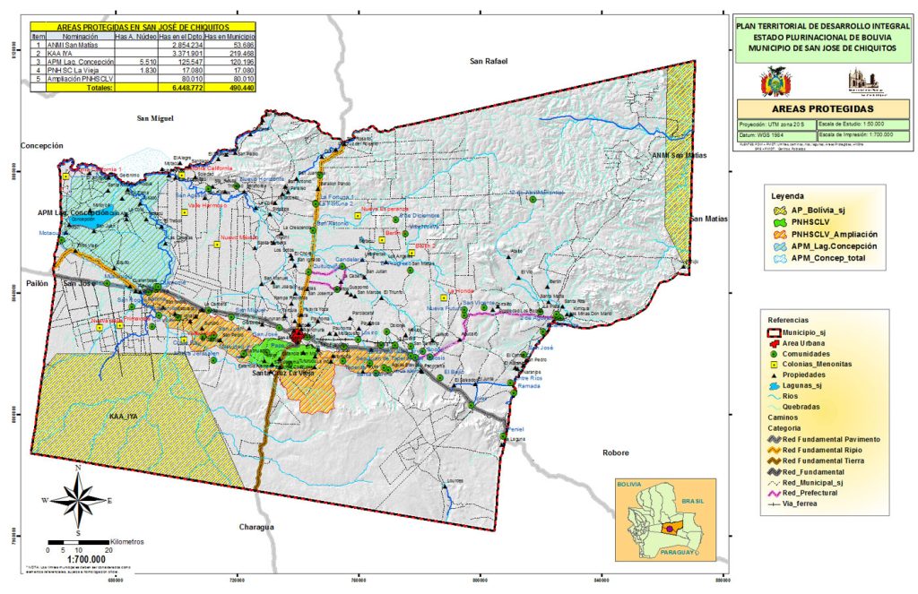
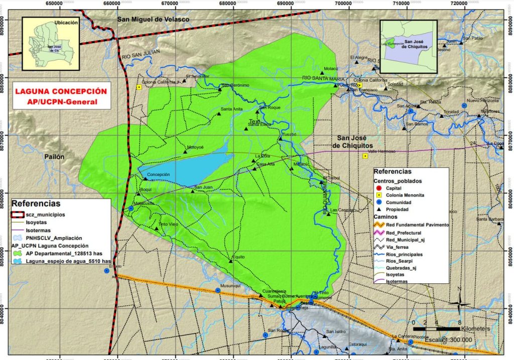
Protected Area Conception Lagoon
Created as a Ramsar Site in 2002 and subsequently recognized as a Municipal Protected Area through various regulations, the Concepción Lagoon It is located in the provinces of José Miguel de Velasco and Chiquitos, encompassing the municipalities of San Miguel, Pailón, and San José de Chiquitos, this reserve covers a total area of 135,566 hectares, making it one of the most significant wetlands in the Bolivian Chaco region.
The lagoon and its associated wetlands represent key ecosystems of the Chaco floodplains, These areas include extensive carandai palm groves and reed beds. It is vital for local wildlife, especially migratory birds that find an essential refuge here during their journey. Furthermore, it is connected to other important water systems, such as the Izozog Wetlands and the Parapetí River.
Laguna Concepción stands out not only for its biodiversity, but also for its cultural richness, with examples of rock art in nearby areas such as María Chica and Motacusito. This protected area reinforces the commitment to conservation and sustainable development, serving as a natural refuge for wildlife and a space of great scenic beauty.
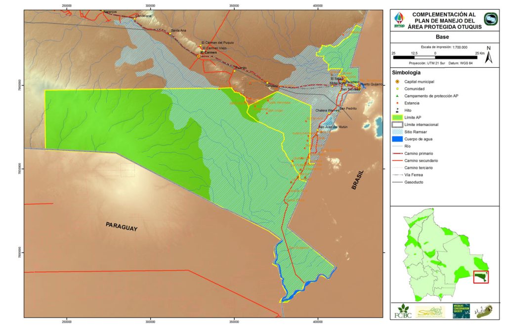
National Park Otuquis
Otuquis National Park and Integrated Management Natural Area, created on July 31, 1997 by Supreme Decree No. 24762, It is located in the Cordillera and Germán Busch provinces, in the department of Santa Cruz, Bolivia. With an area of 1,005,950 hectares (according to its creation decree), this protected area is part of the Gran Pantanal, one of the largest and most biodiverse wetlands in the world.
Its main objective is the conservation of the tropical dry forest and wetlands, These areas are home to emblematic species such as the white-lipped peccary, the marsh deer, and giant otters. Furthermore, Otuquis has been recognized as a Ramsar Site since 2001 for its importance in preserving water resources and its role as a refuge for waterfowl.
The region is characterized by a subtropical monsoon climate, with average temperatures of 25.8 °C and well-defined dry and wet seasons. The park is divided into two blocks: the Otuquis Block, south of Puerto Suárez, and the Río Pimiento Block, to the north, each with unique landscapes that include mountain ranges, plains, and wetlands.
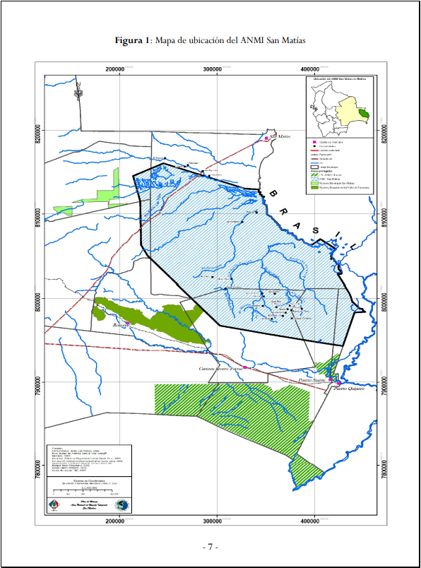
ANMI Saint Matthias
Created on July 31, 1997 by Supreme Decree No. 24734, It is the second largest protected area of national interest in Bolivia. Recognized as a Ramsar Site since September 17, 2001, for the importance of the Bolivian Pantanal, its main objective is to conserve the tropical dry forests and the deciduous forest and savanna ecosystems of the Sunsás mountain range and neighboring areas. Furthermore, it stands out as a tourist attraction due to its biodiversity., with large concentrations of waterfowl, mammals, and threatened species such as the white-fronted piping guan, the marsh deer, and otters. (Source: SERNAP Official Website)
Furthermore, this protected area, with a coverage of tropical dry forests in more than 50%, safeguards unique mountain ecosystems with endemic species and singular landscapes, promoting sustainable productive activities. Its cultural relevance includes the preservation of the territories and traditions of the Chiquitano and Ayoreo indigenous peoples, whose traditional use serves as a model of sustainability. Recognized as an important tourist attraction, the San Matías Integrated Management Natural Area (ANMI) also forms a biological corridor alongside the Pantanal Matogrosense National Park in Brazil, essential for the conservation of fauna, flora, and ecological processes. (Source: San Matías ANMI Monitoring Plan, Ministry of Environment and Water-MMAyA, 2012)
The ANMI San Matías has a Management Plan Prepared between 2007 and 2008 (and published in 2009) with financial support from the Spanish Agency for International Development Cooperation.
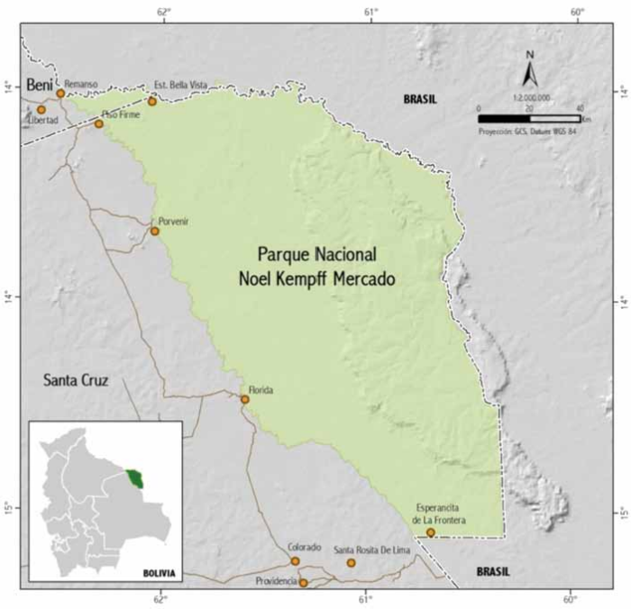
National Park Noel Kempff Market
Noel Kempff Mercado National Park, Initially declared Huanchaca National Park of Flora and Fauna on June 28, 1979, by Supreme Decree 16646, its name was changed to its current one by Law 978 on March 4, 1988. Its area was subsequently expanded through Supreme Decree 21997 in 1988 and Supreme Decree 24457 in 1996. In 2000, it was declared a World Heritage Site by UNESCO. This park, located in the northeast of the Department of Santa Cruz, encompassing the provinces of Velasco (Santa Cruz) and Iténez (Beni), within the municipalities of San Ignacio de Velasco and Baures, was established to protect scenic features such as the Caparúch Plateau, its waterfalls, and the rich diversity of habitats and ecosystems. (Source: SERNAP Official Website)
The Park experienced significant strengthening in its management thanks to a period of co-administration (1995-2005) between the Bolivian National Government and the Friends of Nature Foundation (FAN). During this period, logging concessions were successfully reversed through a process of economic compensation, expanding the park's area to 1,523,446 hectares within the framework of the Noel Kempff Climate Action Project (PAC-NK). This expansion was accompanied by protection and community development programs that promoted governance and social participation.
Currently, the park has planning tools such as the Protection Plan (2013-2017), the Annual Operating Plan (AOP), and an effective monitoring system, in addition to a team of 27 park rangers, 15 of whom come from local communities, which strengthens the relationship with them.